Understanding Hydro-Climatic Impacts on Crops and Hydrology: The LPJmL Model
November 7, 2024

Climate change poses significant challenges to global agriculture and water resources, necessitating advanced tools for assessment and mitigation. Wageningen University & Research (WUR), a leader in agricultural and environmental sciences and the coordinator of the SAFE4ALL project, contributes to the ongoing development and enhancement of the Lund-Potsdam-Jena managed Land (LPJmL) model. This hydrology-crop simulation tool is essential for understanding how shifting climatic conditions impact agricultural productivity and water availability.
The LPJmL Model: A Critical Tool for Decision Making
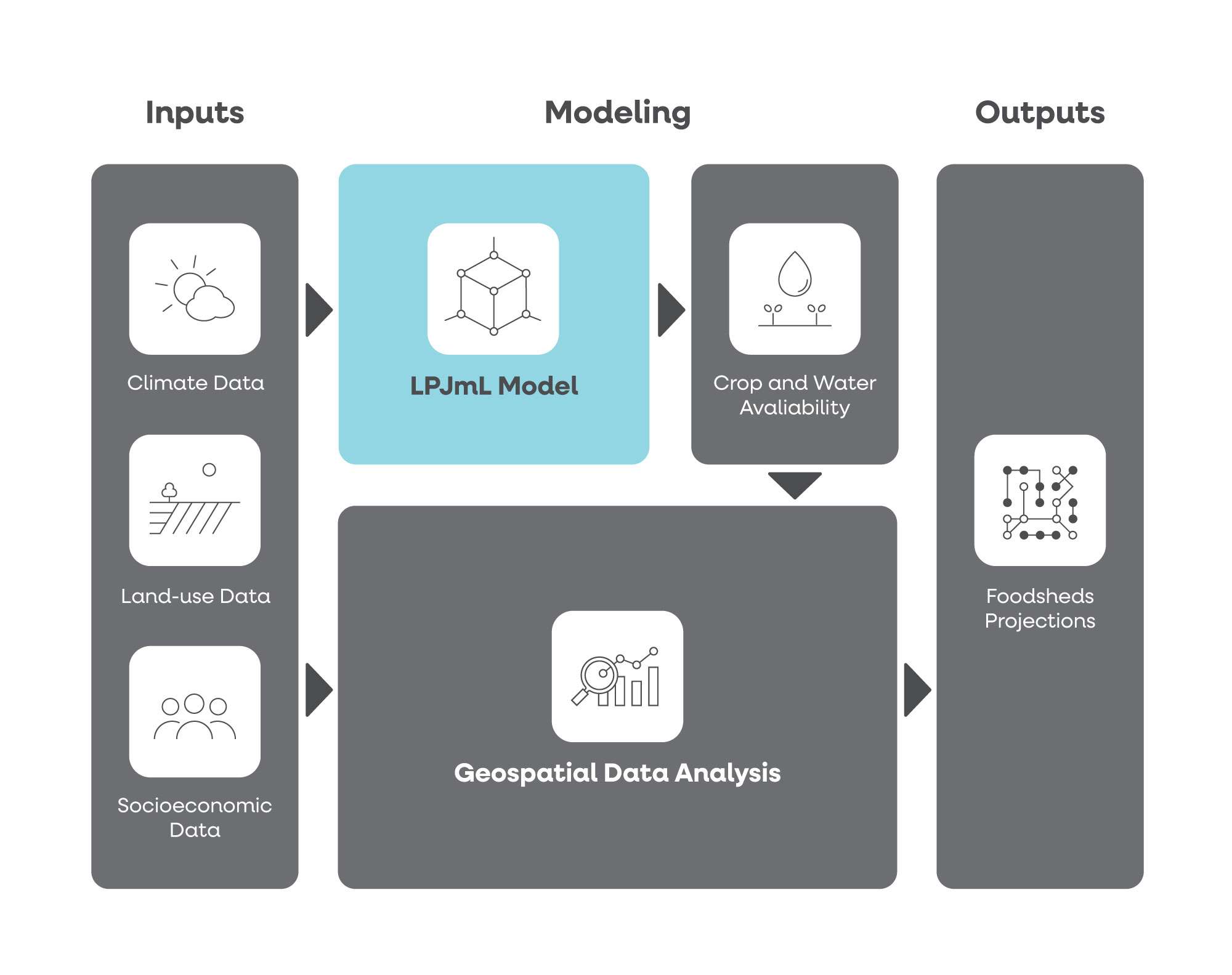
LPJmL is a gridded global model operating at a 5 arc-minute resolution, approximately 10 km at the equator. It integrates data on vegetation, hydrology, and crop growth to simulate yields for 12 major annual Crop Functional Types, including maize, rice, tropical cereals (millet and sorghum), and tropical roots like cassava. By leveraging data on soil properties, land use, river networks, and irrigated areas, LPJmL provides detailed estimates of water availability and crop production.

This model is essential for decision-making, using historical climate data, seasonal forecasts, and long-term scenarios from the Copernicus Climate Data Store. By combining these simulations with socio-economic data such as food and water demand, LPJmL provides a comprehensive view of risks and vulnerabilities in regional food systems, helping stakeholders—from policymakers to farmers—plan effectively for current and future climate conditions.

Introducing the Foodshed Concept
Central to the SAFE4ALL project’s approach is the Foodshed concept—a geographic area from which a population derives its food supply. The Foodshed is not just a physical space; it’s a visualization and analysis tool that helps communicate food availability indicators effectively. By understanding the Foodshed, stakeholders can assess the sustainability and resilience of their food systems, considering both production and distribution aspects.
From Simulations to Services: Co-creating Foodshed Indicators
Building on LPJmL’s output data, the SAFE4ALL project aims to develop a Climate Information Service (CIS) based on the Foodshed concept. During co-creation sessions, stakeholders will identify which output data from LPJmL are most useful for building Foodshed Indicators tailored to their needs. These indicators will improve their decision-making processes, enabling them to design adaptation strategies for land and water management, crop production, and food trade at a regional scale.
By engaging stakeholders in the process and translating LPJmL outputs into actionable insights, the SAFE4ALL project ensures that the tool is relevant and accessible to those who need it most. This collaborative approach supports a wide range of users, from policymakers to agricultural extension officers, in making informed decisions that enhance food and water availability.
Safeguarding Food Security in Tamale: A Case Study
In the Tamale Metropolitan Area of Ghana (outlined in thick black on the map below), the LPJmL-Foodshed CIS provides crucial insights into food availability amid changing conditions. Tamale’s rapid growth, driven by internal and international migration, raises urgent questions about its food supply.
The map depicts maize production and population density in the Northern and Savannah regions. While the area around Tamale shows high population density, maize production varies, with some regions having substantial production and others none. The road network, shown in red, indicates the connectivity of high-production areas to Tamale.
The LPJmL-Foodshed tool will help analyze and visualize how Tamale’s Foodshed meets the city’s food demand now and in the future. Supporting adaptation planning aims to ensure a stable food supply. This tool offers a comprehensive view of regional vulnerabilities and opportunities, supporting decision-making for a resilient foodshed at both seasonal and decadal timescales.
As climate change continues to impact agricultural productivity and water resources, tools like the LPJmL model developed by Wageningen University & Research are essential. By integrating hydrological and crop simulations with socio-economic data, and applying the Foodshed concept, stakeholders can make informed decisions to safeguard food security. The case study in Tamale exemplifies how such tools can support regional planning and adaptation strategies, ensuring resilient food systems for the future.

Wageningen University & Research (Netherlands)
is recognized for its world-class education and research in agriculture, environmental sciences, and sustainability. With a strong focus on innovation and interdisciplinary collaboration, WUR plays a pivotal role in addressing global challenges related to food security, climate resilience, and ecosystem health. The university collaborates with a broad range of partners, combining cutting-edge technology with field expertise to develop solutions that promote sustainable development and improve quality of life worldwide. As the coordinator of the SAFE4ALL project, WUR continues to drive progress in the field of climate adaptation and agricultural sciences.
